
Board Game Academics, March 2026
Published in Vol 3. Issue I.
DOI: https://doi.org/10.70380/p6r2k9s8d4j1f
Vanessa Cozza
Assistant Professor, Director of Communication Studies Online Program
Colorado State University
INTRODUCTION
Two board games published in 1822 combine geography lessons, maps, and games: New York booksellers, F. & R. Lockwood’s The Travellers’ Tour Through the United States and Edward Parker’s The Geographical Pastime of the Complete Tour of Europe. I argue that a side-by-side comparison reveals how these games taught children to associate geographic mastery with British and early American civic and imperial values1 through visual and design-based messaging. For this analysis, I selected Lockwood’s board game because it is “the earliest known board game printed in the U.S.” and “the first board game to employ a map of the U.S.” (Sivils, “What America’s first board game can teach us…”). It also “[imitated] earlier [educational] European geography games” (Sivils). Published within the same year, Parker modeled his American version after Thomas Jefferys Sr’s 1768 The Royal Geographical Pastime of the Complete Tour of Europe.
This analysis uses empirical social inquiry2 through a close examination of Lockwood and Parker’s board games at the Library of Congress. I focused on the game boards’ nondiscursive3 forms of communication, gameplay mechanics, and rhetorical messaging. To assess the board games’ potential use as propaganda, I compared their representations of the nineteenth-century United States, such as historical maps, for evidence of bias or intentional messaging. This analysis begins by positioning mapping as a rhetorical practice and as central to nineteenth-century nation-building.
MAPPING AS RHETORIC
Here, map games shift from reference to interactive persuasion, socializing children as they played. By the mid-to-late eighteenth century, “English publishers [re-casted] their map-games as educational, increasingly aimed at a junior audience by [emphasizing] learning through pleasure” (Baynton-Williams 6). These games arrived at a kairotic moment when “the birth of tourism in Britain, a development largely encouraged by advances in coach travel” (Dove, “Geographical board game,” 4) emerged. Historically, mapmakers have used rhetorical design “to help Americans understand geography” (Schulten, “‘Let us conquer space,’” 39). For example, Abraham Bradley, a post office employee, designed a new map of the United States that captured the nation’s postal network (45; 47). While Bradley literally mapped infrastructure, he also rhetorically constructed economic opportunity—that is, the potential for development. Scholars, such as Susan Schulten and Martin Brückner, demonstrate that nineteenth-century maps functioned not merely as reference tools but as rhetorical instruments that unified national identity and asserted territorial authority. Mapping became relevant because the revolution “enhanced American assumptions about their exceptional, predestined place in world history…[It] also moved the colonies toward nationhood, which generated a need for a unified past” (Schulten, Mapping the Nation, 11; 13). Map-game publishers, thus, needed to consider gameplay mechanics and typography to effectively communicate these ideas through nondiscursive language.
GAMEPLAY AND TYPOGRAPHY
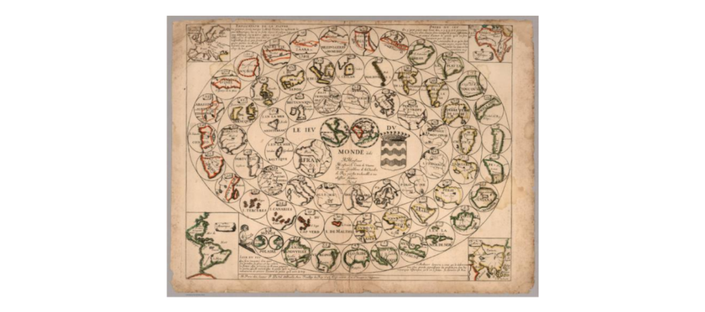
Gameplay itself functions rhetorically. Notably, the race-game format is important because it frames the quest for geographical knowledge as a competition. Lockwood and Parker structurally modeled their board games on a sixteenth-century adult board game titled The Game of Goose, and Pierre Duval’s version, titled Le Jeu de Monde. The spiral track in both versions is characteristic of the race-game format, which later became a popular adaptation in other board games. In spiral-track board games, the first player to reach the end wins. In Lockwood’s board game, the objective was to race across the United States and reach the final space, New Orleans. Players advanced through the map using a teetotum, accumulating moves toward the final destination. The race mechanics position national space as “land” worth conquering and reward progression and arrival as the ultimate achievement.
In Parker’s game, players completed the “tour” by reaching London, the world’s largest city at the time. Because Parker modeled his game on Jefferys Sr’s European version, similarities between the two board games allowed for reconstruction of missing physical elements and gameplay instructions. Adrian Seville and Ashley Baynton-Williams also provide explanations of the objective and rules of Jefferys’ board game, reflecting similar play in Parker’s board game. Players started in the city of Dover, and the first player to reach London won the game (Seville 16; Baynton-Williams 90). Players also backtracked or advanced depending on where they landed on the game’s board. These moves normalized competition, advancement, and setback as outcomes of conquest, aligning spatial movement with merit. While gameplay supports the board games’ subtle messaging (e.g., compete and conquer), the boards’ designs also played a pivotal role in keeping players focused rather than frustrated or distracted by ineffective discursive and nondiscursive language.
Any form of communication loses its persuasive appeal if players cannot read or understand the information presented. Cartographic typography, for instance, serves as a visual cue that ranks information and guides attention toward valuable information. Lockwood and Parker’s boards purposely adhere to cartographic standards to attain and retain player comprehension. Upon opening the fragile, foldable cardboard of Lockwood’s board game, the first noticeable feature is an enlarged, hand-colored map mounted on the left side (see Figure 1).
The map’s colors appeared vibrant and easily distinguishable from the rest of the board’s design. The typography is also notable. Arthur H. Robinson argues that cartographic typography prioritizes clarity and legibility (31-41)—principles that both Lockwood and Parker’s board games follow through consistent font hierarchy and sizing. For example, larger fonts make state and city names easier to read. In addition, capitalized letters and increased font size help draw attention to valuable information. Also, commonly used for maps, the serif font type (in this case, Old Style, Bodoni Book typeface) works well when there is limited space. For instance, although the names of rivers in the board game’s map appear in a much smaller, serif font type, they are still legible. Furthermore, the numbers in circles—that represent 139 cities and towns and mostly appear throughout the mid-to-right columns of the map—use the same font type. Typestyle consistency is key because it keeps readers focused and prevents them from feeling distracted or confused.
Typography is also a considerable characteristic in Parker’s board game. Parker board’s cloth backing and edging certainly set it apart from Lockwood’s fragile cardboard (see Figure 2)4.
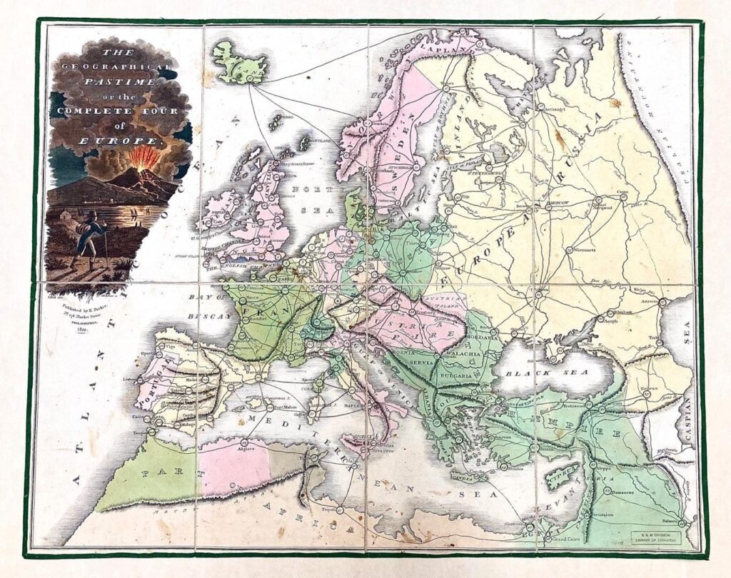
The ivory-toned cloth backing and typographic features support graphic clarity, allowing players to easily identify geographical content. For example, the names of countries and continents are capitalized in a large, serif font type (the Old Style, Bodoni Book typeface), while cities and towns appear in a smaller font size. Here, typography performs ideology by scaling continents, nations, and cities into a hierarchy. Similar to Lockwood’s map, small circles containing consecutive numbers coincide with city names. The numbering allowed players to read and learn about the cities, assisting with recall and guiding players toward mastery. These design strategies accomplished more than facilitating comprehension; they aligned with broader eighteenth- and nineteenth-century pedagogical beliefs that treated play as a legitimate and effective instructional mode.
PLEASURE AND LEARNING
Seventeenth-century philosopher John Locke influenced attitudes about children’s education (Plumb 65; 67), arguing that learning should be both pleasurable and rewarding. Locke stressed that play and recreation would foster a desire to learn (Hoffman 21; 114). This Lockean principle explains how the games’ enjoyment factor became a mechanism through which values took root. Locke’s pedagogy created a market opportunity that publishers quickly exploited, targeting parents’ desire to demonstrate social status through children’s education (Plumb 80). Lockwood and Parker’s board games exemplify the continued resonance of Locke’s ideas among early American parents.
Lockwood and Parker’s board games were designed to be far more intriguing than a textbook. On the right side of Lockwood’s game, the text offered descriptions of the cities’ populations, economies, and trade routes identified on the map. For example, the text for the city of Philadelphia stated that it is located:
on the Delaware river, 138 miles N.E. Washington … [with] handsomely laid out … streets, [crossing] each other at right angles. [The city] contains many public buildings, and its literary and benevolent institutions are numerous and respectable. Regarding the variety and extent of its manufactures, Philadelphia is the largest city in the United States. It contains 110,000 inhabitants. (Lockwood, Cartographer)
This descriptive language was not only informative; words, such as “respectable” and “benevolent,” prepared players to treat geography as a map of character. Even more, the board game’s rules and instructions are another feature that encourages learning. The instructions directed players to read aloud and repeat facts without referencing the descriptions. Specifically, the instructions stated: “name the place without referring to the guide; and to those who are willing to go a step further, they may make it conditional … that the population of each place [is] given” as the game progresses (Lockwood, Cartographer). This approach to learning and remembering content also aligned with the trend set by Pierre Duval’s board game, Le Jeu de Monde. The game’s instructions, for instance, required players to “say the names of the places where [they arrived] and to read the names of the towns found there” (Seville, The Cultural Legacy, 48). Also, in the four corners of Lockwood’s board game, appear “small index maps of the four continents,” which “[assisted] the players in identifying the region they landed on” (Baynton-Williams 40). The game’s rules operationalize ideology, reinforcing habitual memorization and aligning gameplay with learning national facts.
Parker’s board game also served the practical purpose of teaching geographical locations, names of major European cities, and details about those cities. As Baynton-Williams explains, Jeffreys’ map “is complete with the rules, printed from letterpress and pasted on either side of the map; these contain an explanation and directions for play, with a description of each of the 103 steps of the game, ending with 103, London” (90). The accompanying text appears on the side panels of Jefferys’ map with descriptions of 103 cities and towns (Alexander and Martinez 163). Therefore, it is likely that Parker’s map included similar information, appearing separately on its own cloth backing or in an accompanying booklet. The practicality of these board games thus served a broader purpose inspired by Lockean principles: socializing children to meet the demands of a growing economic power.
FORMING CITIZENS
Play socialized children as future citizens—members of society that could learn to respect authority, ascribe to dominant values and beliefs, and help move the nation forward. They “could be raised to become responsible citizens and trusted to exercise their independent judgment” (Fass 16). This meant taking advantage of the opportunity to socialize youth toward British values of self-improvement and progress (Bickham 661). Thus, Locke’s approach would help children assume their membership in society as intellectual adults, and more so during times when Britain’s Industrial Revolution required working bodies. Megan A. Norcia further characterizes Britain’s Industrial Revolution as having benefited from the growth of the middle class. Norcia explains that “middle-class children grew up to occupy important positions in the Empire as its clerks, military officers, missionaries, merchants, and administrators” (10). She adds that growth “required a steady supply of stewards who could ably manage its resources and subjects” (Norcia 10). Children became important for the future of the British Empire because they could fill the roles necessary into adulthood.
Just as the British industry needed imperial stewards, the American nation needed patriotic citizens. The American Revolution inspired American parents to ask, “what kinds of children were needed to maintain the revolution that Americans continued to embrace” (Fass 17). They were seen as the future citizens of the United States (Fass 23; Chudacoff 39), “who later became presidents, doctors, writers, and reformers” (Fass 25). Therefore, children’s games served the purpose of developing skills in leadership, territorial competition, strategic advancement, and spatial dominance (Norcia 8). In Lockwood and Parker’s board games, discursive and non-discursive designs socialized young players to understand American citizenship as an identity grounded in national pride, territorial expansion, and frontier exploration.
NATIONAL PRIDE
In Lockwood’s game, the descriptive language works to inspire national pride and suggest valued moral behavior. The language accomplishes two things: for one, the board game’s text that describes the cities and towns attempts a pathetic appeal (or pathos), potentially, to pique young players’ interests, and more importantly, impart valued attributes that they could emulate. For example, consider the following adjectives that appear in the board game’s description of Philadelphia (referenced earlier): “handsomely,” “respectable,” “literary,” and “benevolent.” While the terms describe the city’s streets and institutions, they also denote civic virtues that embrace personal style (“handsomely”), self-importance (“respectable”), intelligence (“literary”), and charitable behavior (“benevolent”). The decision to use abstract, yet attractive, descriptors is rhetorical. Specific words arouse positive emotions, inspire behavior, and motivate action, inviting children to feel national pride as a personal aspiration.
Second, specific words and phrases also suggest valued moral behavior. To amplify this point, the nineteenth-century philosopher, Ralph Waldo Emerson, even described “the ‘American map’ … [as] the nation’s moral compass, directing the lives of its citizens, realigning their social orientation to each other, and giving new definition to a postwar union” (Brückner 22). In other words, the board game’s descriptive language (or its discursive approach) combined with the pictorial map (or its nondiscursive approach) work together to advise favored appearances and accepted behaviors. This framing explains why language and image must be read together: the map sets the direction, while the prose sets the disposition. While these elements guide behavior and values, they also direct attention to the spatial organization of the nation—particularly its borders and territorial claims.
BORDERS AND RHETORIC
Clearly marked borders function as visual arguments of ownership. As Brückner claims, maps “emerged as a meaningful media platform and popular print genre during the mid-eighteenth century because the map as artifact and the concept of mapping had become involved in social relationships” (24). The visual design principle of contrast helps identify relationships and distinguish between grouped items. For example, compare Lockwood’s 1822 map of the United States to a modern-day map of the country. As expected, a modern map displays more colorful details because, while the country expanded and developed over the centuries, borders and boundaries changed and extended outward. Modern maps not only cover more space, but more importantly, they highlight more directional information and environmental features. In contrast, the purpose of Lockwood’s map was to present fewer interior details and, instead, sharpen perimeters, training the eye to privilege jurisdiction over environment. Conversely, the pictorial map’s distinct borders and boundaries intensify space and place to draw imaginary divisions and hierarchies between groups of people. In support of this, Brückner adds, “American-made maps answered the state and local demands for measuring the physical and social world, establishing order for some while disenfranchising many others” (25). A map’s borders and boundaries can represent a young country’s “growing pains,” war and expansion efforts, and overall, nation-building. Schulten further explains the rhetorical function of borders in maps:
By establishing political borders, historical maps also fostered civic unity by demonstrating a common heritage. The nation could even be said to rely upon geographical and historical knowledge: geography grounds the nation in space, while history roots it in time. National identity depends upon borders, and maps underscored these even when they remained obscure and contested, such as the Western limits of the Louisiana Territory and the disputed border between the United States and Mexico. (14)
Mapmakers purposely highlighted borders to “illustrate territorial forms of sovereignty that developed over the course of the eighteenth and nineteenth centuries” (Schulten, Mapping the Nation 13).
Additionally, colors used in maps have more than just an ornamental purpose; they assist in constructing arguments by grouping sovereignty, marking priority, and signaling potential settlements. Colors create contrast and help draw attention to borders and boundaries, grouping information and making it easier to absorb. The darker outlines in Lockwood’s map, for instance, make borders identifiable, help players distinguish boundaries, and allow easier identification of geographical locations. The map’s design also was inspired by eighteenth- and nineteenth-century mapmakers, such as John Melish, Abraham Bradley, Jr., and David Ramsay. Their maps of the United States look similar. Furthermore, Richard V. Francaviglia discusses how people looking at a map assume that geographical features are accurately placed (3). This suggests maps are often perceived as truthful representations of space.
Colors also help emphasize information (as bold font styles or all caps do in text). The emphasis, while practical, is also symbolic, and its more subtle purpose depends on the specific content that requires attention. Lockwood’s map design symbolizes the settlers’ migration to the West. More specifically, the pictorial map’s states and territories are colorfully outlined in yellow, pink, dark pink, blue, and dark blue. The outlining also appears to have been purposefully pressed to darken the colors. The color scheme of the map mostly reflects Schulten’s description of Ramsay’s work: “The states are harmoniously colored, clearly arranged and suggestively unified” (“‘Let us conquer space,’” 51). However, some of the states are not outlined, nor are they shaded, and other states vary in value or brightness. This nondiscursive approach accomplishes two goals: first, the vibrant hues of lined and shaded colors aid in the clear visibility of marked borders and boundaries, and second, the coloring guides the ability to easily distinguish between states, territories, and coastlines. Nothing new, vibrant colors, such as the ones used in modern road maps and atlases, allow viewers to not only identify content, but also it permits them to trace directional information. Though in the case of the board’s map, directional information does not involve tracing freeways and highways as it does in a modern road map. Instead, the board map’s design urges tracing borders and boundaries. As a result, and immediately noticeable, the map’s design clearly differentiates the eastern states from Maine to Georgia, the midwestern states from Ohio, Indiana, and Illinois to Alabama and Mississippi, Missouri and Louisiana as the most western states, and Florida, Michigan, the Northwest, and Arkansas as the territories. Here, legibility serves as a lesson plan, positioning the nation as a project with edges to pursue.
Interestingly, the ability for players to identify borders and boundaries is not as important in Parker’s map as it is in Lockwood’s map. Certainly, Parker’s lightly shaded colors and ivory-toned background contribute to the map’s readability—another practical aspect of the board game that likely allowed players to easily see the content. Yet, the country and continent’s boundaries simply appear outlined in pencil, indicating coastline borders of the North Sea, the White Sea, the Bay of Biscay, the Baltic Sea, the Gulf of Venice, the Mediterranean Sea, the Black Sea, and the Caspian Sea. In addition, yellow, pink, light, and dark greens, light and dark browns shade countries and parts of Africa. Consequently, the penciling and shading do not make the map as vibrant and appealing as the colors used in Lockwood’s map do. By marking what land belongs to the country, the color lays out what land still needs claiming. This visual logic of ownership and expansion is reinforced not only through borders and color but also through representations of who is meant to move through, claim, and explore that space. In contrast, Parker’s map teaches expansion by inviting identification with an explorer’s persona.
THE PIONEER IMAGE
In Parker’s game, the illustration in the top left corner does the ideological work. It leads me to consider Gregory Clark’s description of the pioneer: “[An] American pioneer’s encounter with the continent was an encounter with land” (13). Even more interesting is how the idea of the pioneer shifts from the frontier explorer to the recreational tourist. Parker’s board game fully reflects Clark’s remarks on the American pioneer’s encounter. It presents the entire European continent, and in the top left corner, appears the illustration of the (American) pioneer. The illustration romanticizes the idea of the brave and adventurous explorer—the one who discovers and conquers. The messaging in Parker’s game is not as obvious as the British board games that Norcia analyzes, which imposed imperialistic beliefs. However, Parker’s game still supports the idea that discovery and conquest led to the benefits of expansion and colonialization. In sum, this is the most important lesson here: finding new land means taking advantage of new opportunities and resources. For that reason, why not inspire players with an illustration that captures the pioneer’s experience? In this case, the illustration says it all; it converts travel into ideological performance, involving courage, risk, and reward.
Parker’s board game also mostly relies on relay (or the text and image working together) to convey its message that traveling and exploring are valuable pursuits. Relay anchors a viewer’s gaze and supplies a caption that tells them how to interpret what they see. First, placing the illustration in the upper left side of the board immediately directs players’ attention to that corner. The capitalized letters and increased font size also help emphasize the illustration’s significance and aid in attracting the eyes. More importantly, however, is the text itself because it appears in white lettering on top of the image, making it easier to spot and read the caption. Furthermore, while the typography for the game’s title in Lockwood’s board is a fancy, serif font type like contemporary Academy Engraved LET, the title in Parker’s board takes a simpler, yet still attractive approach. Specifically, it remains consistent in the Old Style, Bodoni Book typeface, and its only capitalized words are “PASTIME,” “COMPLETE TOUR,” and “EUROPE.” These words also appear in a larger font size than the rest of the text. The lettering underscores the board game’s subject, that is, the exploration of Europe.
Moreover, the image is not gender-neutral, portraying the subject of exploration as only a male pursuit. By casting exploration as masculine, the game narrows who is invited to imagine themselves as a pioneer. In fact, John D. Cox confirms the messaging of gender roles and expectations in his discussion of travel literature, claiming, “[Travel] traditionally has been a male pursuit and thus not equally available to both sexes” (12). Parker’s illustration implies acceptable gendered behaviors and stereotypes a bit more subtly. The board game’s image attempts to arouse the fascination and anticipation of exploration for boys. While the descriptive language in Lockwood’s board game attempted to enhance pathetic appeal, nondiscursive means do the trick here. In Parker’s case, the image alone has the rhetorical effect of arousing emotions. For example, the illustration depicts a volcanic eruption with red and yellow colors that represent lava shooting from a dark brown volcano. Red and orange wavy lines show pathways of lava running down the volcano. Most notable is the foreground in which a male figure appears with a hat, backpack, and walking stick. The figure’s parted legs imply movement, and his body turned toward the image’s background suggests he is an explorer who is witnessing the volcano’s eruption. The lone male figure with his equipment defines exploration as a masculine-reserved activity. It also romanticizes the notion of discovery and conquest, directly supporting the idea that finding new land is synonymous with seizing new opportunities. This visual functions as the central propaganda piece of Parker’s game, and it participates in a broader cultural discourse that also framed exploration as a worthy and aspirational pursuit—one reinforced through contemporary travel literature and guidebooks.
As is the focus of Michelle Beissel Heath’s work, the relationship between games and books proved profitable for the consumer market (193-194). Thus, travel guides fit right in with board game maps, and I situate Lockwood and Parker’s board games in this literary context. Jane Dove’s analysis of five British board games published between 1770 and 1809 (Jefferys’ board game being one of them) helps me explain this point. Dove notes that “[all] the sites existed in reality and therefore, in this sense, the pastime could be viewed as a type of travel guide” (1). The board game’s maps were accurate enough that they could serve as travel guides and promotion materials. Dove adds, “Although advertised as geographical pastimes, … the games were also types of travel guides, for example, promoting watering places, country seats, ancient monuments, natural curiosities and towns and cities, all of which real tourists explored in growing numbers” (Dove 16). Both Lockwood and Parker’s board games have another purpose and reflect what Apostolos Spanos identifies in his conceptualization of studying games. In terms of the “function and use of the game,” Spanos explains, “Many game sets and game equipment … might be used for purposes not related to their original function” (36). By promoting specific cities, monuments, and natural curiosities, these board games not only educated young players, but also, they prepared them to become future tourists and consumers of global travel, revealing how play functioned as an early form of cultural conditioning. Read this way, the games doubled as a brochure, teaching children where to go and what to desire when they arrived at their destinations.
CONCLUSION
Taken together, the games reveal distinct rhetorical strategies. Comparatively, Lockwood instructs through borders, while Parker persuades through bodies. Their games functioned as cultural blueprints, shaping geography, behavior, morality, and social hierarchy. In Lockwood’s game, the use of vivid color to outline physical borders of the expanding nation helped construct psychological boundaries, fostering a sense of ownership and superiority over the land essential to a nation built on expansionism. Parker’s game, by contrast, relied on illustration to reinforce hierarchical divisions based on gender, implicitly framing exploration and pioneering as masculine pursuits. Though seemingly innocent, these games were powerful instruments in the construction of nineteenth-century self-identity. While this analysis has addressed the intent embedded in their design and messaging, the next stage of research lies in uncovering their impact on actual players. This is an important next step because it tests whether designed intentions became lived beliefs. Future archival research, such as letters, diaries, or educational records, may help illuminate how young players interpreted and internalized these messages.
- By British and American imperial values, I mean eighteenth and early nineteenth century beliefs of territorial expansion, economic power, and political stability. ↩︎
- Empirical social inquiry focuses on the systematic collection and interpretation of real-world evidence. Thus, I read game boards as rhetorical artifacts, where mechanics, typography, and cartography operate together to produce ideology. ↩︎
- Nondiscursive forms of communication include visually driven components, such as layout/structure (or placement), typography (or the appearance of the text), and illustrations (or images, drawings, and pictures), that are more symbolic in nature and are not as straight forward as text or discursive means. ↩︎
- T. Birch hand-colored Parker game board’s eight panels and J. H. Seymour engraved them, making the board visually stunning. ↩︎
WORKS CITED
Alexander, Isabella and Cristina S. Martinez. “A Game Map: Object of Copyright and Form of
Authority in Eighteenth-Century Britain.” Imago Mundi, vol. 72, no. 2, 2020, pp. 163-180.
Baynton-Williams, Ashley. The Curious Map Book. University of Chicago Press, 2015.
Bickham, Troy. “Preparing for an Imperial Inheritance: Children, Play, and Empire in
Eighteenth-Century Britain.” Journal of British Studies, vol. 60, July 2021, pp. 658-688.
Brückner, Martin. The Geographic Revolution in Early America: Maps, Literacy, and National Identity. University of North Carolina Press, 2006.
—. The Social Life of Maps in America, 1750-1860. University of North Carolina Press, 2017.
Chudacoff, Howard P. Children at Play: An American History. New York University Press, 2007.
Clark, Gregory. Rhetorical Landscapes in America: Variations on a Theme from Kenneth Burke.
University of South Carolina Press, 2021.
Cox, John D. “Introduction.” Traveling South: Travel Narratives and the Construction of American Identity. University of Georgia Press, 2005, pp. 1-18.
Dove, Jane. “Geographical board game: promoting tourism and travel in Georgian England and
Wales.” Journal of Tourism History, vol. 8, no. 1, 2016, pp. 1-18.
Fass, Paula S. The End of American Childhood: A History of Parenting from Life on the Frontier to the Managed Child. Princeton University Press, 2016.
Francaviglia, Richard V. Mapping and Imagination in the Great Basin: A Cartographic History. University of Nevada Press, 2005.
—. “Introduction.” In Mapping and Empire: Soldier-Engineers on the Southwestern Front, edited by Dennis Reinhartz and Gerald D. Saxon, University of Texas Press, 2005, pp. xv-xx.
Heath, Michelle Beissel. “The United States as Wonderland: British Literature, U.S.
Nationalism, and Nineteenth-Century Children’s and Family Board and Card Games.” Playing Games in Nineteenth Century Britain and America, edited by Ann R. Hawkins,
Erin N. Bistline, Catherine S. Blackwell, and Maura Ives, SUNY Press, 2021, pp. 193-194.
Hoffman, A. Robin. “Introduction: To Strike the Eye and Form the Mind.” Georgian and Victorian Board Games: The Liman Collection, edited by Ellen Liman, Pointed Leaf Press, 2017, pp. 21-24.
Locke, John. Some Thoughts Concerning Education and Of the Conduct of the Understanding. Edited by Ruth W. Grant and Nathan Tarcov, Hackett Publishing Company, Inc., 1996.
Lockwood, F. & R., cartographer. The Traveller’s Tour Through the United States. F. & R.
Lockwood, 1822. Map. Library of Congress.
Norcia, Megan A. Gaming Empire in Children’s British Board Games, 1836-1860. Routledge, 2019.
—. “Puzzling Empire: Early Puzzles and Dissected Maps as Imperial Heuristics.” Children’s Literature, vol. 37, 2009, pp. 1-32.
Parker, Edward, bookseller. The geographical pastime or the complete tour of Europe.
Edward Parker, 1822. Map. Library of Congress.
Plumb, J. H. “The New World of Children in Eighteenth-Century England.” Past & Present, no. 67, 1975, pp. 64-95.
Robinson, Arthur H. The Look of Maps: An Examination of Cartographic Design. ESRI Press, 1980.
Schulten, Susan. “‘Let us conquer space’: Visual thinking as nation building in the early United States.” Journal of Historical Geography, vol. 77, 2022, pp. 38-54.
—. Mapping the Nation: History and Cartography in Nineteenth-Century America. Chicago: University of Chicago Press, 2012.
Seville, Adrian. “Geographical Pastimes: Two early English map games.” IMCoS Journal,2010, pp. 15-18.
—. The Cultural Legacy of the Royal Game of the Goose: 400 Years of Printed Board Games. Amsterdam University Press, 2019.
Sivils, Matthew Wynn. “What America’s first board game can teach us about the aspirations of a young nation.” The Conversation, 8 May, 2024, https://theconversation.com/what-americas-first-board-game-can-teach-us-about-the-aspirations-of-a-young-nation-228581.
Spanos, Apostolos. Games of History: Games and Gaming as Historical Sources. New York: Routledge, 2021.

Vanessa Cozza
Director of Communication Studies Online Program
Colorado State University
Vanessa Cozza is the Director of the Communication Studies Online Program at Colorado State University, where she currently teaches a range of online courses, including public speaking, rhetoric, and a senior capstone on visual communication. She previously taught a variety of writing and rhetoric courses. Her current research investigates how nineteenth-century board games reflect the ongoing process of reinventing and redefining American society through cultural artifacts and embody narratives of the nation’s struggles and accomplishments, revealing insights into history and the rhetorical power of design-based messaging. These games also helped transform the United States’ identity and culture.